22 July, 2018
There have been many improvements in how weather experts predict the path of hurricanes, powerful storms that form in the ocean.
However, forecasters still struggle when trying to estimate one quality of a coming storm: its intensity.
Intensity measurements would help people prepare for flooding and deadly winds, like those of Hurricane Maria last year. Maria killed an estimated 4,465 people, severely damaged the electrical power system and caused $90 billion in damage in Puerto Rico.
Steve Bowen is the director and weather expert for the insurance company Aon Benfield's Impact Forecasting team. He said it is helpful to know where a hurricane is going, but more information about its intensity is needed.
"We sort of have half the circle filled in, and we need to get that other half filled in," Bowen told the Reuters news service.
Some climate scientists have said that warming sea and air temperatures have added more energy to the storms. And this might affect intensity predictions.
Kerry Emanuel is a climate professor at the Massachusetts Institute of Technology. In a recent academic paper, he wrote: "Climate change potentially affects the frequency, intensity and tracks of" hurricanes and other similar storms.
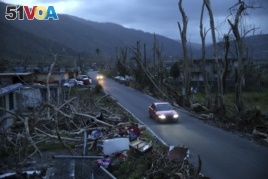
FILE - In this Sept. 26, 2017, file photo, neighbors sit on a couch outside their destroyed homes as sun sets in the aftermath of Hurricane Maria, in Yabucoa, Puerto Rico.
In 2017, the U.S. government's National Hurricane Center reported that it had failed to correctly predict the sudden intensification of the 2016 hurricane called Matthew. That storm strengthened very quickly, with winds reaching up to 270 kilometers per hour. It caused major destruction in the Caribbean, including killing more than 1,000 people in Haiti, according to Reuters.
Scientists say there are several scientific models for predicting hurricane intensity, but they are all of limited use.
The current science of tracking a storm's path depends heavily on information about conditions on its edges. But, intensity is based on what is happening in the middle of it.
Generally, measurements are taken one of three ways. Sometimes researchers fly a ‘hurricane hunter' aircraft into the storm. Other times, they use a device called a weather buoy to measure wind speeds as a storm passes over. Or, they get information from satellites.
One project to gather more information to predict intensity is the Cyclone Global Navigation Satellite System, or CYGNSS for short. CYGNSS is a group of eight low-orbit satellites. The American space agency, NASA launched it in 2016.
Earlier satellites had trouble measuring ocean surface winds at the center of storms. Heavy rain at the center often weakened their signals, NASA officials said.
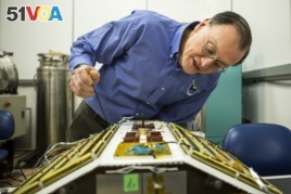
Christopher Ruf, Director of the Space Physics Research Laboratory and Atmospheric, Oceanic and Space Sciences Professor at the University of Michigan, inspects CYGNSS, February 12, 2015.
Christopher Ruf is a lead investigator with CYGNSS and a climate science professor at the University of Michigan. He noted, "For storms that are changing really quickly, you could miss something like rapid intensification."
NASA designed CYGNSS to measure surface winds in and near the center of tropical storm systems. Researchers said that having more satellites means they can pass over the storms more often. And the low-orbit satellites are closer to the storms. So, experts get more real-time information to use for predicting intensity.
At present, researchers are focusing on the 2017 season when hurricanes severely affected Texas, Florida and Puerto Rico. Storms caused hundreds of billions of dollars in damage. And researchers are re-examining information gathered from CYGNSS to see how it affected the quality of the forecasts and how it can be better used to predict intensity.
CYGNSS could be fully operational next year, researchers said.
I'm Pete Musto.
Jon Herskovitz first reported this story for the Reuters news service. Pete Musto adapted it for VOA Learning English. Caty Weaver was the editor.
We want to hear from you. What more do you think researchers will learn about how to predict the intensity of hurricanes? How will this help people better prepare for future hurricane seasons? Write to us in the Comments Section or on 51VOA.COM.
_____________________________________________________________
Words in This Story
hurricane(s) – n. an extremely large, powerful, and destructive storm with very strong winds that occurs especially in the western part of the Atlantic Ocean
forecaster(s) – n. someone who predicts something, such as weather, after looking at the information that is available
insurance – n. an agreement in which a person makes regular payments to a company and the company promises to pay money if the person is injured or dies, or to pay money equal to the value of something, such as a house or car, if it is damaged, lost, or stolen
academic – adj. of or relating to schools and education
potentially – adv. in a way that makes it possible for something to be real
frequency – n. the number of times that something happens during a particular period
track(s) – n. the path along which someone or something moves or proceeds
according to – prep. as stated, reported, or recorded by someone or something
rapid – adj. happening quickly
tropical – adj. of, relating to, occurring in, or used in the part of the world that is near the equator where the weather is very warm